
4km north-west of Coachford village, just off route R618 and on the road to Bealnamorrive village, is Mullinhassig Wood and Waterfall. The wood straddles the townlands of Aghavrin (Aghabullogue parish) and Shanavagha (Aghinagh parish) along the Glashagarriff River. Coillte owned, the wood is open to the public, and visitors include locals and tourists alike.
This scenic place of local beauty has been known for generations. In 1837, Samuel Lewis wrote ‘The glen of Mullinassig abounds with beautiful and romantic scenery, both its sides are richly adorned with wood, and at its head, deeply seated amid towering rocks, is a little mill, below which the river forms a fine cascade, and a little lower falls into a beautiful lake.‘ Since Lewis’s time, the mill is gone, but the glen and river very much remain.

Mullinhassig is the anglicised version of the Irish Muileann an Easaigh, meaning ‘Mill of the Waterfall’. The mill was located a short distance upriver, and was there in 1654 -56, when Cromwellian recorders noted its existence in the Civil Survey, describing it as the ‘Mill of Assagh’. Two hundred years later, Mullinhassig still had a mill (or rather had two, to be more precise). An examination of the 1848 and 1850 Valuation Office house books reveals Denis Murphy occupying a boulting mill (dimensions 22½ ft by 18ft) and a tuck mill (17½ ft by 16 ft) at Mullinhassig. Boulting was a process whereby meal was sifted (or boulted), or flour separated from grain. Tucking (or fulling as it is also known) involved the cleansing of fibres, such as wool, to eliminate dirt and impurities, and to make textiles be of thicker quality. This particular boulting mill was categorised as being ‘relatively new and ordinary in finish, slated and constructed of stone or brick, with lime mortar’. The adjoining tuck mill, as the older of the buildings, was categorised as ‘not new and slightly decayed, but in good repair’, slated and also built of stone or brick, with lime mortar.
With technological advances, creameries began to appear in mid-Cork around the turn of the twentieth century. The Murphys of Mullinhassig adapted to these changes, and the mill became a creamery, at least for a short period. The 1901 Census tells us that brothers John Murphy and Denis Murphy of Dromacullen, Aghinagh, were a creamery manager and creamery hand respectively. Ten years later, the 1911 Census describes Denis Murphy as a creamery engine driver, while John Murphy had moved away to become the creamery manager at Kilcolman Creamery in neighbouring Aghabullogue. Today, a dwelling house and garden occupy the former mill site(s). Evidence of the area’s milling past can still be seen by examining the early Ordnance Survey maps, or even physically in the remains of mill races and sluice gate pillars.
Adjoining the road at Mullinhassig Wood is a small car park. The information sign tells visitors that they have arrived at Coill Pholl an Easaigh (Poulanassig Wood), and that Mullinhassig Waterfall is a short distance to the west (0.75km). Not exactly true, because this is Coill Mhuileann an Easaigh (Mullinhassig Wood) and the forest paths will bring the curious visitor to Poulanassig Waterfall. Perhaps it’s high time for new signage! Mullinhassig Waterfall is not here. It is out of sight upriver, adjoining the former mill site, but it can be heard when passing along the road, particularly in times of high water volume.
Welcome improvements by Coillte in recent years include connecting the two walking paths, which both lead from the car park towards Poulanassig Waterfall. The upper path has received a hard core surface in places, and gives spectacular views of the wood, river and waterfall below, before ending abruptly behind the waterfall. It is now possible to descend to the lower path from the upper path, and then continue on to the waterfall, or to return by way of the lower path back to the car park. Care should be taken when using the upper path, particularly in places where steep sides are exposed, and appropriate outdoor footwear is recommended.
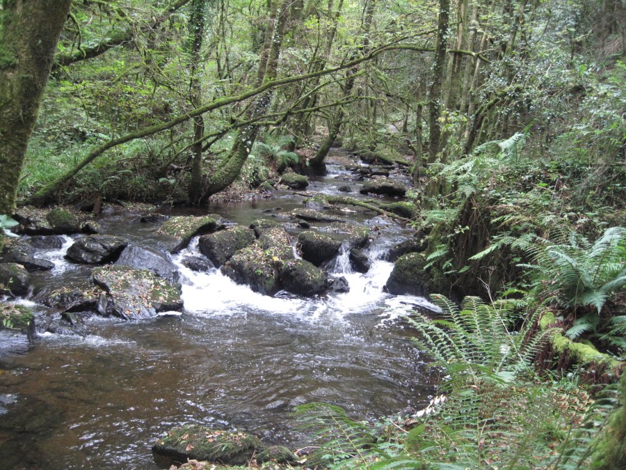
Walking along the lower path, which descends steeply from the car park, brings the walker alongside the Glashagarriff River (Glaise Garbh, meaning ‘rough stream’). This river has humble beginnings as an upland stream, before it joins the much larger River Lee, some kilometres to the south. The lower path becomes muddy in times of rain or in winter, thus the need for decent footwear.
After walking a short distance along the lower path, we emerge from the trees into an open area, covered with scrub and undergrowth, where the river meanders sharply to the left. Here were ‘Bowen’s Pond’ and ‘Poulachorane Waterfall’. We know they existed firstly from the Ordnance Survey name book (c. 1840), which describes a pond of water in the River Clashagorrave about 10 chains (0.2 km) south of Poulanassig [Waterfall], and with the pond having at its mouth a waterfall. Secondly, the pond is depicted on the 1842 surveyed Ordnance Survey map, as indeed is the waterfall and named ‘Poulachourane’. The map also depicts channels leading from the pond to fields to the south of the wood. Clues still exist today in the sandy, gravel filled soil in this area, which is wet and marshy in places; and in the remains of a retaining wall; and by the large stones strewn nearby within the river. At some point during the eighteenth or nineteenth century, a retaining wall of natural stone was constructed, damming the Glashagarriff river and forming a pond (probably named for the landowning Bowen family of Oak Grove, Carrigadrohid). Channels fed water through the wood, parallel to the river and down into fields to the south, for irrigation and water supply. In a time of little machinery, this would have been an impressive but exhausting project, conducted with the most basic of tools and hard labour. During the second half of the nineteenth century, the retaining wall was intentionally removed, or simply collapsed due to neglect or even flood damage. We shall possibly never know for sure. Bowen’s pond and Poulachourane waterfall disappeared, and the river found a natural meandering course, forming a shallow area which has since been used for summer paddling by generations of local youngsters.
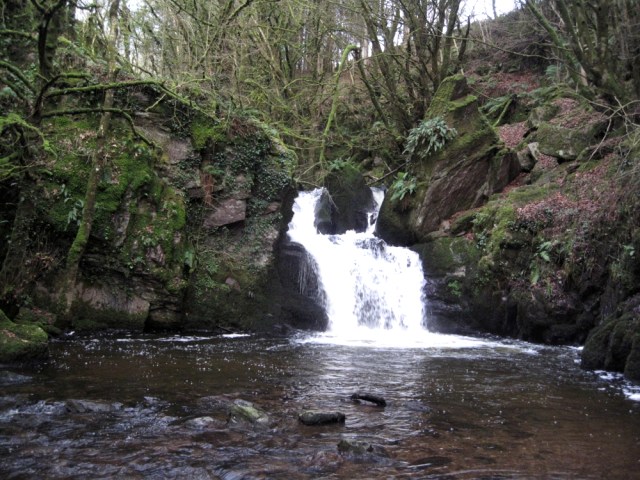
A short distance upriver is a majestic moss-covered old tree, nestled on a river island, which from a distance appears to sit in the water. This is probably one of the oldest living specimens within the wood. Continuing on, the Glashagarriff appears more active, as it gurgles and rushes over rocks, creating foam lines and tumbling into pools containing small fish. After clambering over rocks and uneven root-covered ground, our journey is almost at an end. We enter a leaf-covered open space beneath the trees, with the thundering sound of Poulanassig waterfall as a cacophony in the background. Rounding the corner gives a glimpse of this cataract. Water tumbles over rock, and falls into the pool from which the waterfall derives its name. High, rocky, wooded banks on three sides form a natural amphitheatre in this corner of paradise. This is Poulanassig, Poll an Easaigh, meaning ‘pool of the waterfall’. It is the ‘lake’ referred to by Lewis in 1837. The Irish Tourist Association Survey of 1944 contains some local folklore, and tells us that a mermaid in the form of a salmon resides in the pool. If approached quickly in late evening, she can be seen combing her hair on a stone ‘stool’ to the left of the waterfall. On sensing strangers, she dives to the bottom of the pool. Near the waterfall’s brink is a boulder, said to be her ‘table’. Another version has the mermaid enticing unwary anglers to the bottom of the pool, where they spend their days releasing fish from the hooks of other anglers. This is said to be the reason why no fish are ever caught here.
Hidden away at the eastern end of Mullinhassig Wood is Aghavrin Clapper Bridge. These types of pedestrian bridge are composed of stone piers, which support flat slabs. This particular bridge served local residents for generations, allowing them to safely cross the Glashagarriff for both trade and social purposes. Local knowledge has it that the bridge collapsed in relatively recent times, due to flood damage. More can be read here: Aghavrin Clapper Bridge.
Finally, a short distance downriver of Mullinhassig Wood is Aughariddera Bridge (Aughariddera or Áth an Ridire meaning ‘Ford of the Knight’). A ford existed across the Glashagarriff for centuries, where the bridge now stands. On 4 August 1580, during the Second Desmond Rebellion, this was the location where the force of leading rebel Sir James FitzGerald was defeated by that of Sir Cormac McTeige MacCarthy, Lord of Muskerry. This sixteenth century encounter is sometimes locally referred to as the ‘Battle of Mullinhassig’.
SOURCES
- C. Murphy, I.T.A. Topographical and General Survey (Irish Tourist Association, 1944)
- Census Records for Ireland, 1901 and 1911, National Archives of Ireland website http://www.census.nationalarchives.ie/ (accessed 26 February 2019)
- GeoHive Mapviewer, Ordnance Survey Ireland website http://map.geohive.ie/mapviewer.html (accessed 26 February 2019)
- Ordnance Survey Name Books (c. 1840)
- Robert C. Simington, The Civil Survey A.D. 1654-1656 … Muskerry Barony, Co. Cork (Irish Manuscripts Commission, Dublin, 1942)
- Samuel Lewis, A Topographical Dictionary of Ireland (2 vols, London, 1837), i
- Valuation Office Books 1824-1856, National Archives of Ireland website http://census.nationalarchives.ie/search/vob/home.jsp (accessed 26 February 2019)
