
By Doug Lucey
The Peake Line is a stretch of road between the village of Peake and Mullinhassig Wood, and follows a straight course along much of its route. Some may not be aware it was constructed c. 1846-7, during the Great Famine, at a time of severe local distress. Intended as a local famine relief work, the proposed road resulted in differences arising between the members and supporters of two famine relief committees (Aghabullogue and Magourney), and culminated in correspondence to government and newspapers.
On 15 October 1846 presentment sessions took place at Coachford Courthouse amid chaotic scenes. Included in the presentments granted for Magourney (commonly now known as the Coachford area) was £900 for a new road to Coolacullig Bog.1 Within a month a notice appeared in the Cork Constitution, requesting local magistrates, gentry and cess-payers to meet at Mullinhassig on 13 November, to discuss the merits of a new line of road and ‘prevent alleged misapplication of public funds and injury to the labouring poor’.2 Another letter was sent to the Cork Examiner by ‘a friend to suffering humanity, and a lover of justice’ contending that both Aghabullogue and Magourney relief committees were in favour of the new road, with the route to be decided by the county surveyor, or a board of works engineer. The writer of this letter was critical of the delegated official, and alleged they were pressurised by others for selfish purposes. The writer went on to express concern that the outcome would be labourers employed in a bog in bad weather, when the choosing of an alternative route would have shortened the distance, and prevented unnecessary outlay of £600.3
The four-hour meeting at Mullinhassig on 13 November unanimously resolved that inspection of two competing lines from ‘Mullinhassig to Colthurst’s sandpit’ indicated north line no. 142 to be shorter, less expensive, commanded better materials, was maintainable at less cost and essentially more useful. It was felt that constructing a road through a bog at such time of year would endanger the health or sacrifice the lives of labourers. Those present also contended that competing lines of road had passed the Coachford court sessions subject to a government engineer laying out the best route for public advantage; and that one route had subsequently been brought to the notice of Captain Broughton, with there being suggestion that a more circular and expensive line of road was proposed to effect drainage of Coolacullig bog, for personal advantage. The Mullinhassig meeting condemned this proposed route for having at one end a series of curves not justified by topography, and deviating to intersect the bog and aid draining and reclamation, extending road distance, tripling expenditure, and endangering labourers.4
On 18 November Aghabullogue resident Thomas Crooke of Aghavrin went public on the issue, writing to both the Constitution and Cork Examiner, and enclosed a copy letter dated 26 October as forwarded to Jos. C. Walker (Secretary of the Board of Works) outlining grievances of Aghabullogue relief committee members.5 We are told the proposed road (from Mr Colthurst’s gravel pit at Larchfield Cross, Peake to where Mr Good’s watercourse crossed the Mullinhassig road) was to be part of the line between Cork and Millstreet, shortening existing distance and avoiding several hills. Application was made by both Aghabullogue and Magourney parishes, as the road would run through both. Aghabullogue relief committee was to have suggested the starting and ending points of the new road, but felt an engineer should decide the route taken. Magourney relief committee was said to suggest the road run through [Coolacullig] bog, south of a potentially more direct route, and supposedly to connect to Coachford village.
Crooke’s correspondence indicated the southern route was felt by Aghabullogue committee members or supporters as too expensive, against the public interest, and deprived access to landed proprietors to the north. A direct route on the northern side of the bog was considered best, and the acting engineer should disregard suggestions from those with personal interests, and choose the best route for public convenience. A reply to the letter to the Board of Works Secretary on 26 October had been received, stating the matter was under consideration, and the arrival of an officer to determine the route was awaited. However, work was alleged to have commenced on laying a route through the bog, without proper inspection, investigation into merits, examination of materials and facilities, consideration of expense, or prior pledge. This was not acceptable to those on the Aghabullogue side. Employment should be given judiciously, providing for the comfort of labourers, and securing the greatest return for expenditure incurred, which would not occur as things stood, with labourers finding it impossible to work in comfort or safety, and a waste of public funds occurring. Legal means to resist these works would be pursued if necessary, and works should not proceed until sanctioned by competent authority and founded on proper inspection.6
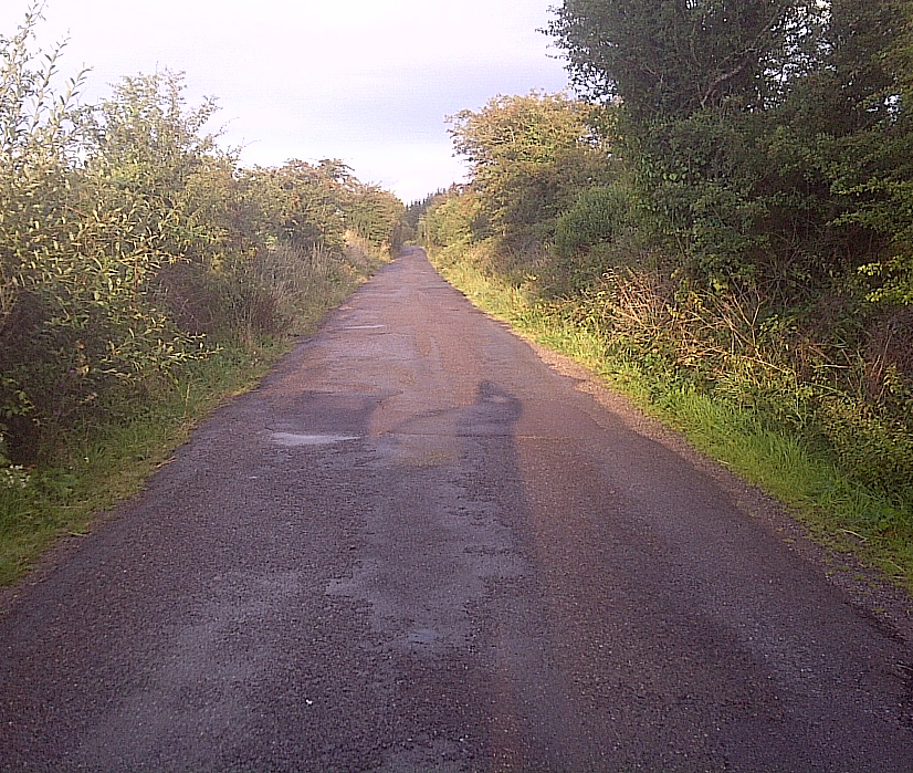
In the absence of further correspondence, it is difficult to ascertain whether the dispute was resolved. Available documentation reflects the views of members of the Aghabullogue relief committee, or supporters, and it must be remembered that the opinions of Magourney relief committee members are not available to consider. Examining ordnance survey maps and conducting fieldwork on the ground suggests the route was reconsidered and Aghabullogue concerns entertained, or some compromise at least reached. The completed road appears to cross a boggy area for a short distance at the western end, and then runs along the northern edge of Coolacullig bog. It is located generally within Aghabullogue civil parish, or straddles both civil parishes. The road is roughly equidistant between the Aghavrin-Peake road and the Coachford-Coolacullig road, and is not connected to the latter. What it does serve is an unfortunate reminder of local politics coming into play, at a time of extreme distress for many in the locality.

1 Cork Constitution (CC), 17 Oct. 1846; Cork Examiner (CE), 19 Oct. 1846.
2 CC, 10 Nov. 1846. By late 1846, separate relief committees had formed for the civil parishes of Aghabulloge and Magourney.
3 CE, 11 Nov. 1846.
4 CC, 14 Nov. 1846; CE, 18 Nov. 1846.
6 CC, 19 Nov. 1846; CE, 20 Nov. 1846.
