
By Doug Lucey
Located across the road from Coachford National School, is the site of Magourney medieval church, later a chapel of ease, following the parish’s incorporation as a particle of Aghabullogue. It is difficult to date the site’s religious beginnings, but mention is made in the Rolls forming part of Pope Nicholas’s taxation (year 1291) of the churches of Mustlyn, and that one mark was the due of the ‘church of Nadryd’.
Mustlyn (also ‘Muskerrylynn’, or in the native tongue ‘Múscraighe Ui Fhloinn’) was an ancient name for this part of Cork, once ruled by the O’Flynn’s. The territory was also known as ‘Múscraighe Mittaine’. The MacCarthys and their followers would come later, to chase out the former rulers, and take control of Muskerry.
As for the name Magourney (in Irish ‘Maigh Guairne’), we do not know exactly what it means. ‘Maigh’ means plain, an area of flat land, obviously a reference to local topography. ‘Guairne’ has been interpreted as referring to topography, or perhaps to an individual, such as ‘Dorney’. The truth is we don’t know for sure, and we probably never will. Papal taxation documents (c. 1302-1306) mention ‘Magorne’. Another document, a Close Roll dated to the reign of Edward II, refers to land held in ‘Magurne’ around the year 1309.
What is the connection between Mustlyn, the ‘church of Nadryd’, and Magourney? Well … Mustlyn had the church of Nadryd, and Magourney civil parish had a townland called Nadrid. There is no other townland of similar name (as far as I know) in Cork county. The closest is Ballynadrideen near Charleville. Nadrid townland today extends from the banks of the River Lee, northwards into Coachford village, ending about 100 metres south-east of the boundary wall of Magourney church and graveyard. Magourney parish itself was located within Mustlyn. ‘Nadryd’ and the local modern townland of Nadrid are surely one and the same.
Is ruined Magourney church the ‘church of Nadryd’, which existed in 1291? There’s a strong possibility that part of the existing church is, or perhaps it was an earlier church, which was later replaced by the existing ruined church. Perhaps the church was within the boundaries of Nadryd/Nadrid at the time, as boundaries were known to occasionally change over time. At the very least, Magourney church adjoined Nadryd, just as it does today. This would suggest that on this site was the parish church of Magourney, and that it existed in 1291, during the medieval period. If it existed in 1291, by implication it existed before that, perhaps for quite some time.
Was Magourney church established by the Normans, as these colonists made their way westwards through the Lee Valley? The Coachford area would very much have been on the frontier, and subject to attacks by the hostile Irish. Or was it a religious site dating back to the beginnings of Christianity in Cork, upon which a church came to be founded? Christianity is thought to have come into the Lee Valley during the earliest days, with men of religion following the river, and establishing centres of worship and hermitages in areas of the valley. Perhaps Magourney is one of these very centres or hermitages.
One of the earliest depictions of a church at Magourney can be seen on The description of Muskery, a sketch map dated c.1587, now held by the National Maritime Museum in Greenwich, London. The Second Desmond Rebellion had ended in 1583. Munster was in ruin, following years of war, and the result was famine, death, and decimation of the population. Leading rebel Sir James Fitzgerald of Desmond had been captured by the MacCarthys and his force annihilated but a few kilometres to the west. The plantation of Munster was under way, but the local MacCarthys escaped, by siding (willingly or not) with the Elizabethan administration. The church appears ruined in the sketch map. Perhaps it was ruined, through destruction, neglect, or for some other reason.
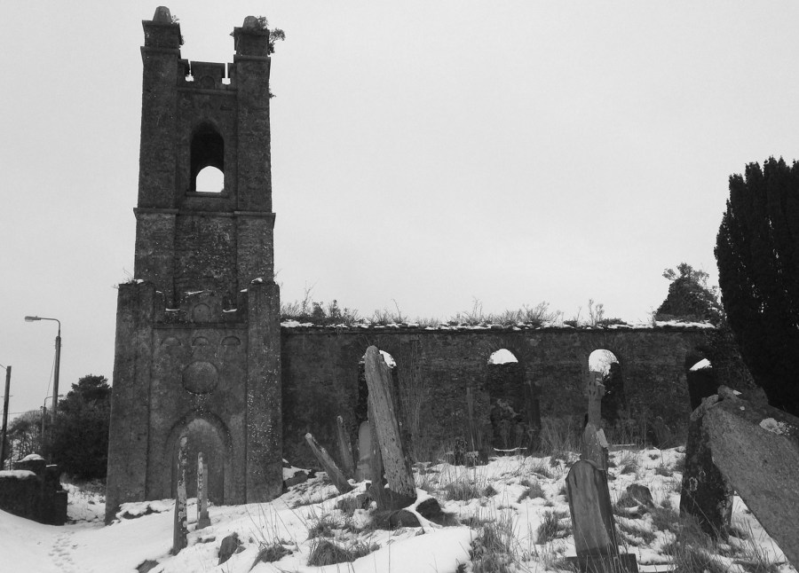
Magourney is sometimes locally referred to as ‘the old Protestant church’. To an extent, that’s correct. However, before the sixteenth-century, there would have been no distinction between Catholic and Protestant. This was once a church of one faith, on a religious site dating back centuries. After the Reformation, Magourney would go on to become a Church of Ireland parish place of worship, and in 1717 it became separate from Aghabullogue. By Order dated 22 June 1728, Magourney perpetually united with adjoining Kilcolman parish. So as a religious site, it has arguably gone full circle, from a place of singular faith, to an professed Protestant one, and continued as a local place of burial both for Catholics and Protestants, who now lie side by side in their hundreds, perhaps thousands, remembered by memorials, grave markers, or by nothing at all, interred on all sides of the graveyard.
Charles Smith mentions a new parish church here in 1750, which suggests that it replaced (partly at least) a former structure. Magourney church was later extensively repaired with Board of First Fruits funding and donations c.1818/9. Church deconsecration followed c.1857, when adjacent Christchurch was built and opened for Divine Service.
The oldest known headstone is to a person named ‘Folley’, who died on 29 June 1724 aged 28. Another headstone, interestingly dated to the same year, is in memory of William Burnet of Somersetshire. Notable interments include Mary Laura Cross (infamous Coachford Poisoning case), and local antiquarian Herbert Webb Gillman from Clontead More (an article on him can be read here: https://acrheritage.info/blog/famous-people/herbert-webb-gillman-1832-1898/ Interments within the graveyard are rare these days, the most recent being a private interment of ashes in 2019.
In the north-eastern segment is ‘Famine Corner’, where local unfortunate victims of the Great Famine (1845-52) were buried. We have no idea as to how many were interred here, or their identities. All that exists in their memory are two parallel rows of grave markers. A memorial stone, unveiled by ACR Heritage in 2013, marks the famine burial plot, and is inscribed simply with the words ‘Maigh Guairne’. Another project undertaken by ACR Heritage was to survey the graveyard in 2013, with the assistance of Eachtra Archaeological Projects. The survey results were digitised, uploaded, and can now be freely viewed at https://historicgraves.com/graveyard/magourney/co-mory .
Today the site is surrounded by the village of Coachford, and it is easy to forget that this religious site probably predates this modern and progressive village by 500+ years. Indeed one of the very first mentions of Coachford can be found in the Freeman’s Journal dated 10 January 1822. We learn that on the previous Thursday, 3 January, magistrates and gentleman of Muskerry had met at Magourney parish church ‘near Coachford’, to discuss whiteboy activities within the locality.
In recent years, Magourney church and graveyard were well maintained through the good work of community and county council employees, and by the efforts of volunteers. Sadly however, the graveyard has since fallen into a serious state of neglect. More ominously, the site (particularly the church) has become prone to spates of vandalism. This conduct is unacceptable and should stop. It is disrespectful to those interred and their families. It is also disrespectful to us in general, because it is an unwarranted intrusion upon and interference with our own heritage.
We owe it to the memory of those who have passed before us, and to having pride in our locality, to take steps to arrest this decline and neglect. Such an important place of spirituality, heritage and history deserves more, and it should once again become a focal place within our community, as it was for centuries, long before Coachford ever came into being.

Please consider helping the newly formed Magourney Graveyard Committee. It would be greatly appreciated. Email acrheritage@gmail.com; or send a PM to https://www.facebook.com/acrheritage/ ; or text or contact 086-0456554.
