

Hidden away and barely visible through the dense undergrowth of Mullinhassig Wood, are the remains of Aghavrin clapper bridge. A jumble of stones and a slab protruding from the waters of Glashagarriff River. Once it enabled local people to cross the river safely. Today it functions as an unintended dam, preventing flood debris from floating downriver.
Clapper bridges are stone uprights or piers, upon which stone slabs are placed, creating narrow footbridges across rivers or streams. This idea is not new, and clapper bridges have been constructed in Ireland at least from medieval times. Some continue in use to this day, and some were constructed in recent centuries. The word clapper is said to derive from the latin claperium, meaning ‘pile of stones’.
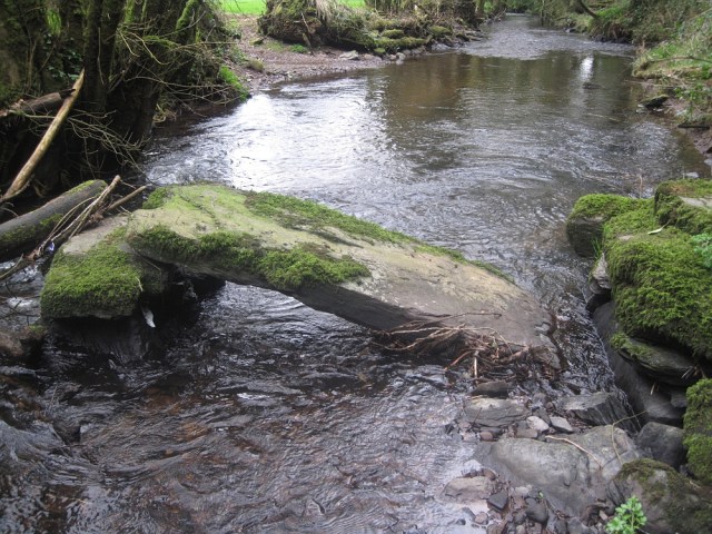
We cannot be sure how old Aghavrin clapper bridge is. It predates the Great Famine, and is marked as a ‘footbridge’ on the 1st edition Ordnance Survey map, surveyed in 1841. The chances are that the bridge was there long before that. Some locations in rivers and streams were used as fording points for generations, and some had stepping stones which were later replaced by clapper bridges. If this were the case at Aghavrin, it would make it the location of an ancient river crossing.
The bridge continued to be used during the 20th century, and was also marked as a ‘footbridge’ on the 25 inch Ordnance Survey map, as surveyed in 1901. According to local information, it was still in use within living memory, until it was permanently damaged by flood debris in more recent times. Floods are nothing new to this river, with its name ‘Glashagarriff’ being anglicised from the Irish Glaise Gharbh, loosely meaning ‘rough rivulet’. Floods affected this little bridge many times over the centuries, and each time it would have been repaired, until disuse finally allowed the river to win.
Clapper bridges are relatively rare in Ireland. Other recorded Cork instances include a medieval bridge near Buttevant, which is associated with Ballybeg Abbey; another is located in Rahoonagh townland near Ballymakeera; two fine versions have been repaired and are used today by walkers in Ballingeary village; and yet another is situate in the townland of Drom an Ailigh near Gougane Barra. What makes Aghavrin clapper bridge particularly unique, is the possibility that it is the only officially recorded clapper bridge in the barony of Muskerry East.
The bridge formed an important part of the local infrastructure for generations. According to the 1841 Census, the population in Aghavrin townland was 346 people at that time. Local footfall was high. People travelled smaller distances. This bridge connected the parishes of Aghabullogue and neighbouring Aghinagh. It allowed the inhabitants to transact business and secure items of necessity, at a time when people shared and bartered what they had, and when access to shops was not as easy or perhaps was unaffordable to many. The bridge allowed people to socialise and communicate in times of need, compared to the modern day when many of us communicate without leaving our homes or use vehicles to travel to our destinations.
In a way, today’s image of Aghavrin clapper bridge in a ruinous state is ironically appropriate. It mirrors perhaps a broken connection with our local past; with something which once existed; and with something now all but lost to memory, with the passing of time.

SOURCES
- Archaeological Survey Database, National Monuments Service website http://webgis.archaeology.ie/historicenvironment/ (accessed 16 April 2018)
- Heritage Bridges of County Cork (Cork County Council Heritage Unit, 2013)
- P. David Sweetman (ed.), Archaeological Inventory of County Cork Volume 3: Mid Cork (Stationery Office, Dublin, 1997)
